Featured
Closed
Terms of Reference (PDF)
Read the full vacancy document online or save a copy to your device.
PDF not displaying? Open the document in a new tab.
overview
About this position
Project: CROPS4HD Phase II
Location: Lindi and Mtwara Regions, Tanzania (Lindi Municipal Council, Mtama DC, Mtwara DC, Masasi DC, and Nanyumbu DC)
1.0 Background
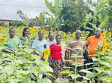
The CROPS4HD II Project (Consumption of Resilient Orphan Crops for Products for Healthier Diets – Agrobiodiversity for Improved Food Security and Nutrition) aims to improve the livelihoods, food security, and nutrition of rural communities — especially women — through the sustainable use and conservation of farmers' varieties and neglected and underutilized species (NUS). The project promotes agroecological approaches that strengthen climate resilience while ensuring diversified and sustainable food systems.
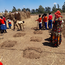
Access to reliable and sustainable water sources is a critical enabler of resilient agriculture and improved nutrition. Adequate water supply supports crop production, livestock, and household needs, directly influencing livelihoods and community wellbeing. However, communities in the Lindi and Mtwara Regions continue to face challenges in accessing sufficient and reliable water due to environmental variability, limited infrastructure, and climate impacts.
To address these challenges and enhance evidence-based planning, the programme intends to commission a Water Survey Consultancy to map and identify existing water sources in the target project areas. The consultancy will provide detailed data on the quantity, capacity, and quality of the water sources to inform project implementation and community-level decision making.
Location: Lindi and Mtwara Regions, Tanzania (Lindi Municipal Council, Mtama DC, Mtwara DC, Masasi DC, and Nanyumbu DC)
1.0 Background
The CROPS4HD II Project (Consumption of Resilient Orphan Crops for Products for Healthier Diets – Agrobiodiversity for Improved Food Security and Nutrition) aims to improve the livelihoods, food security, and nutrition of rural communities — especially women — through the sustainable use and conservation of farmers' varieties and neglected and underutilized species (NUS). The project promotes agroecological approaches that strengthen climate resilience while ensuring diversified and sustainable food systems.
Access to reliable and sustainable water sources is a critical enabler of resilient agriculture and improved nutrition. Adequate water supply supports crop production, livestock, and household needs, directly influencing livelihoods and community wellbeing. However, communities in the Lindi and Mtwara Regions continue to face challenges in accessing sufficient and reliable water due to environmental variability, limited infrastructure, and climate impacts.
To address these challenges and enhance evidence-based planning, the programme intends to commission a Water Survey Consultancy to map and identify existing water sources in the target project areas. The consultancy will provide detailed data on the quantity, capacity, and quality of the water sources to inform project implementation and community-level decision making.
key responsibilities
What you'll be doing
- Inception Phase:
- Review relevant project documents and existing literature on water resources in Lindi and Mtwara regions
- Develop a detailed survey methodology, sampling framework, GIS approach, and data collection instruments in consultation with Local Government, RECODA, and SWISSAID Tanzania
- Data Collection:
- Conduct fieldwork to gather primary data on rivers, wells, boreholes, springs, dams, and other water sources across 64 sites in five districts
- Collect secondary data from local government authorities and relevant institutions
- Engage community members and key stakeholders for participatory data collection and validation
- Mapping and Analysis:
- Use GIS and remote sensing tools to geo-reference and produce detailed maps of all identified water sources
- Assess each source's functionality, seasonality, water quality, storage capacity, and potential for agricultural and domestic use
- Analyse patterns, challenges, and opportunities related to water access, utilisation, and sustainability
- Target Sites (64 sites/villages total):
- Lindi Municipal Council – 10 sites/villages
- Mtama District Council – 17 sites/villages
- Mtwara District Council – 7 sites/villages
- Masasi District Council – 20 sites/villages
- Nanyumbu District Council – 10 sites/villages
- Reporting and Validation:
- Compile findings into a draft report with maps, tables, and analytical summaries
- Present findings to RECODA and SWISSAID Tanzania (SAT) for review and validation
- Finalise the report incorporating stakeholder feedback with clear, actionable recommendations
- Deliverables:
- Inception Report – outlining the detailed methodology, tools, and work plan
- Draft Survey Report – including preliminary findings, geo-referenced maps, and initial recommendations
- Final Survey Report – comprehensive document with refined analysis, detailed maps, and actionable recommendations
- Presentation of Findings – a PowerPoint presentation summarizing key findings for RECODA, SAT, and relevant stakeholders during the validation workshop
requirements
What we're looking for
- Advanced degree in Water Resources Management, Environmental Science, Geography, Hydrology, or a related field
- Minimum 5 years of demonstrated experience in water resources assessment and mapping
- Proven proficiency in GIS tools and remote sensing for geo-referencing and spatial analysis
- Experience conducting field surveys and engaging with rural communities and local government authorities in Tanzania
- Strong analytical, report-writing, and data visualisation skills
- Fluency in both English and Swahili
how to apply
Submit your application
Submit your application electronically to info@recoda.or.tz with subject line: "Application – Consultancy for Water Sources Mapping (CROPS4HD II)". For more information, please contact RECODA at the email address above.
Send to: info@recoda.or.tz
Subject line: Application – Consultancy for Water Sources Mapping (CROPS4HD II)
Applications closed
The deadline for this position has passed. Browse other open vacancies below.